Viewing entries tagged
Table Mountain

Table Mountain - April 17, 2021

Table Mountain - April 17, 2021

Table Mountain is an epic Columbia Gorge hike with over 17 miles and 3,400 vertical feet starting at Bonneville Dam. We hiked Table over 12 hours on April 17, 2021 with perfect conditions. From the summit, five volcanoes were on display (Hood, Jefferson, Adams, St. Helens, and Rainier).

View from Table Mountain’s summit with Mount Hood, Bonneville Dam, and the Columbia River.

View from Table Mountain’s summit with Mount Hood, Bonneville Dam, and the Columbia River.

Click here to view photos from the hike.

Table Mountain - January 14, 2018

Table Mountain - January 14, 2018

We started the 2018 hiking season on January 14th with Table Mountain on the Washington side of the Columbia Gorge near Bonneville Dam. With the closure last year of the usual trailhead at Bonneville Hot Springs, our team of four hikers took a longer approach starting at the Bonneville Trailhead near the dam. At the end of the day, we hiked close to 16 miles with 4,320 in vertical feet (compared to eight miles and 3,350 feet on the old route).

The conditions for January were spectacular as we started down the trail – partly cloudy skies, a light breeze, and a few rays of sun. After a half mile, we joined the Pacific Crest Trail and walked in the footsteps of thru-hikers from the Mexican border traveling north. The path passed through areas logged in recent years and by several small bodies of water – including Gillette Lake.

Gillette Lake from the Pacific Crest Trail.

Gillette Lake from the Pacific Crest Trail.

After several hours we passed by the junction to the old trail and eventually reached the base of the Heartbreak Ridge Trail to the summit. From here the fun/pain kicked into high gear and we gained a significant amount of elevation over a short distance. The wind also started to pick up and the temperature dropped.

Sign marking the Heartbreak Ridge Trail.

Sign marking the Heartbreak Ridge Trail.

At the saddle below the talus field scramble, a sustained wind howled just out of reach above our heads. We also entered into a thick cloudbank, eliminating our chance of seeing any volcanoes from the summit.

Our team on the summit.

Our team on the summit.

Above the rocks, we continued onward to the summit sign, took the requisite selfie, and then found a calm harbor out of the wind to enjoy an IPA. For the descent, we looped to the west side of the mountain and followed the trail along a steep cliff face before going back into the woods and rejoining the PCT.

View from the descent down the west side of the loop.

View from the descent down the west side of the loop.

Several hours later we were back at the parking lot and on our way as the sun began to set behind the mountains on the Oregon side of the river. We ended up spending about eight hours on the trail. Key takeaways: the first few miles of the longer approach to Table are significantly more scenic than the old route from the hot springs; 16 miles is a long way to go for the first hike of the year; and January hiking in the Gorge is always worth doing over watching NFL playoff games (unless it’s the Seahawks). We decided to go hiking, despite missing an afternoon of excellent playoff football. In the car ride home, we listened to the final minutes of the Minnesota Vikings-New Orleans Saints game on the radio. Something about hearing the play-by-play of the final minutes – rather than watching it at home – was even more exciting than seeing it on TV.

Click here for more photos from the hike.

Table Mountain - March 12, 2016

Table Mountain - March 12, 2016

By Dan Douthit (@dtonedouthit)

Looming over the western end of the Columbia Gorge is the aptly named Table Mountain, offering a challenging 3,200 vertical feet of elevation gain, varied terrain, and a guaranteed boost towards getting conditioned for even higher peaks. I've hiked Table many times before, usually on bluebird spring or summer days. On a clear day the view at the top is second to none in the Gorge, with the potential for seeing five volcanoes. On March 12, 2016, the conditions were far from ideal, but the experience was no less epic.

Our group rendezvoused at the Bonneville Hot Springs Resort around 8:30am. After paying for a $5 parking pass (redeemable for credit in the lodge after the hike), we hit the trail. The sky was overcast and dry, but the ground remained damp from earlier rain. Less than five minutes in - still within sight of the parking lot - I dunked my boot into a well-camouflaged mud hole. Fortunately my Vasque-brand boot performed like a boss and the mud slurry didn't creep into my socks.

The first few miles were pleasant as the trail snaked through the forest and gradually gained altitude. We passed by several spurs - one leading down a powerline road; the other toward Aldrich Butte. Past the two-mile mark we reached the junction with the Pacific Crest Trail. On this day we didn't encounter any thru-hikers, but we did see the skeleton of a teepee/lean-to-like structure likely used by PCTers.

We took the PCT for about another mile before reaching the true base of Table and the crux of the day's work. From this point, a spur - formerly known as the "Heartbreak Ridge" Loop (not after the Clint Eastwood movie about the Grenada invasion) - rockets up through the forest. Whether out of laziness or a moral aversion to switchbacks, the designers of this stretch decided to retain the natural steepness of the slope in their trail design. The end result is one of the steeper sustained segments I'm aware of in the Gorge.

We kept a steady pace and began our ascent up Heartbreak, pausing several times for a quick breather. The sky remained overcast in all directions, but we began to catch views of the river and the surrounding mountains below the cloud cover. We eventually reached Sacagawea Rock and a flat section of the trail offering stunning views to the east and west.

Then, back in the woods, we pushed onward until we reached a talus field of large stones covering the hillside. The established trail evaporates through this field, forcing hikers to choose their own path between a series of cairns with wooden markers. Stepping slowly to avoid a rolled ankle or smashed knee, we proceeded to the top of the rocks and returned to the forest for the final push to the summit.

With less than a quarter miles to go, we reached another junction and turned toward the top. Upon exiting the woods, we came to the flat "table" part of the mountain. No longer protected by trees, we started to experience strong winds buffeting the summit plateau and surrounding ridges. We quickly traversed across the top of the plateau to reach a sharp drop-off overlooking the Columbia. Upon reaching this point - and just as I was about to eat a fake meat roast beef sandwich washed down by a Fort George IPA - an angry wind howled in from the west. And then a shotgun blast of hail came down followed by blowing snow and diminished visibility.

We made a group decision to eat fast (and refrain from drinking the IPAs), and make tracks down the mountain without delay. Rather than walk across the top of Table and complete the Heartbreak loop, we retraced our steps and went straight down the talus field. The full loop down the west side of Table affords incredible views of the Gorge, but on this day there was nothing to see. We also wanted to avoid additional exposure. The prospect of climbing down a mile of wet rocks above a precipitous drop didn't sound appealing to any of us.

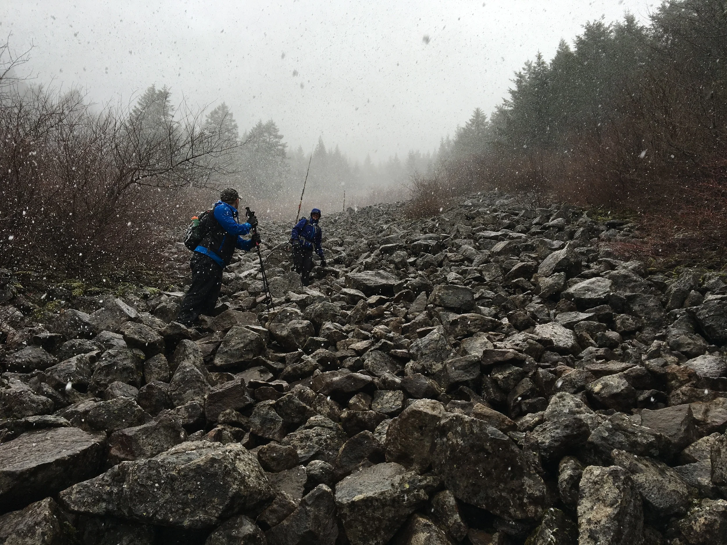
As we descended, the snow began to stick and oscillate in size - from near sleet to large, Charlie Brown-style flakes. Once back in the forest below the rocks, the air temperature warmed to above freezing and we enjoyed a steady rain for most of the rest of the hike. Our journey back to the parking lot was muddier than earlier in the day, but uneventful. In a few places the trail seemed more like a streambed than a hiking path as gravity pulled the afternoon's precipitation toward the Columbia. Upon reaching Bonneville Hot Springs, we used our parking passes for credit in the hotel coffee shop and then headed back to Portland.

Overall - despite the wind, rain, and snow - we won the day. If you wait for a sunny day in March, you may never go hiking anywhere in Cascadia. Equipped with Gore-Tex and gloves, we weathered the inclement conditions with only minimal discomfort. My key lesson learned for future trips is to use more caution when stepping near running water on the trail. My muddy boot dunk 100 yards from the car could have been a major game-changer.

Click here for more photos from the hike.