Viewing entries tagged
Ryan Yambra

Hardy Ridge - May 21, 2016

Hardy Ridge - May 21, 2016

By Ryan Yambra (@Ryambra)

Beacon Rock State Park is one of the most popular destinations in the Columbia River Gorge. With landmarks ranging from Hamilton Mountain to Beacon Rock, the 5,100-acre natural area has something for everyone.

But fewer people make the trek up Hardy Ridge. Tucked away at the Equestrian Trailhead, the route up Hardy Ridge gives hikers big views, spring wildflowers, and more than 2,000 feet of elevation gain without the crowds to show for it.

This particular Saturday in May was a soaker with heavy rain and low clouds. And while the views were less than spectacular, that didn't stop us from hitting the trail. 

This hike begins by heading north on the Equestrian Trail. After a slow, winding climb of about a mile, the wide path meets a junction with the West Hardy Ridge Trail. To make a loop, we ignored the western path and continued along the Equestrian Trail another half mile until reaching the East Hardy Ridge Trail.

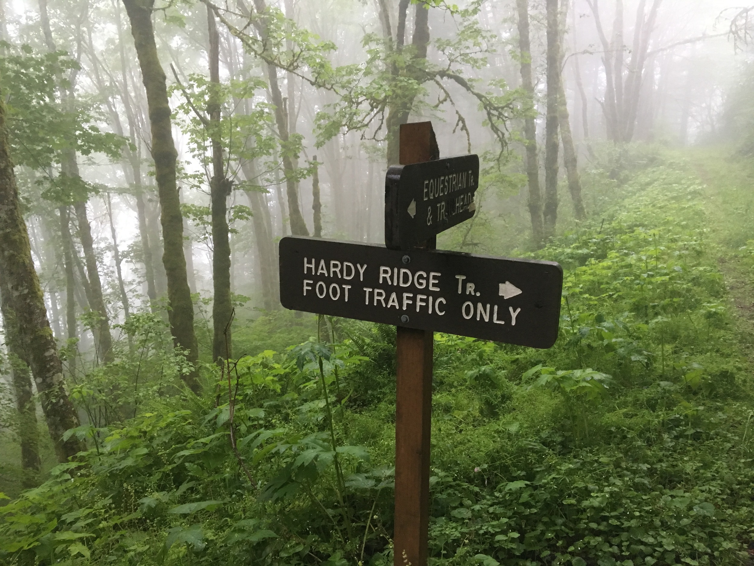
Once hitting the East Hardy Ridge Trail, which resembles a dirt road, we continued our gradual ascent. Eventually, the trail meets a junction with a connector marked ‘foot traffic only.’ As the light drizzle turned into a shower, we took the connector trail towards the top of the ridge. 

After about a half mile, this well-established path meets a four-way junction. Here, you can head up towards the Hardy Ridge summit or descend back into the trees.

Normally during late spring, a trip up to the summit gives hikers amazing views with sights of nearby Hamilton and Table mountains. On a clear day, Mount Adams is also visible. Sadly, the weather was too poor to enjoy the views up top. We chose to have lunch at the junction and head back down.

To make it back, we descended under the trees on the west trail along the western side of the ridge.

After a gentle downhill trek, the path spit us back out onto the Equestrian Trail. From there, we hiked slowly back down to our cars.

Hardy Ridge has plenty to offer hikers without the crowds of other nearby destinations. On the day, our total mileage was a bit under eight miles with the trail just to ourselves. Rain or shine, Hardy Ridge should be a destination for any hiker looking to try something new.

Click here for more photos from the hike.

Dog Mountain - March 5, 2016

Dog Mountain - March 5, 2016

By Ryan Yambra (@Ryambra)

Dog Mountain is among the most popular hiking destinations in the Gorge. During springtime, the mountain boasts abundant wildflowers as well as multiple vistas offering expansive views of the Gorge. But make no mistake--with about 2,800 feet of elevation gain in less than three miles, Dog Mountain is a steep hike requiring some fitness.

Due to Dog Mountain’s (relatively) lower elevation, this hike is a great early season challenge. For this day, we expected the worst as the weather forecast hinted at wind and rain. But we encountered the opposite: unusually warm temperatures, moderate cloud cover, and zero rain. We didn’t even make it a mile before we chose to take off some of our layers.

Beginning at the Dog Mountain Trailhead, the path starts off steep. After .7 miles of climbing, freeway traffic sounds begin to fade as the trail reaches a junction in the forest. At this point, the trail splits in two directions: an older route marked ‘more difficult’ and a newer, ‘less difficult’ one. We were up for a challenge, so we took a left up the ‘more difficult’ trail. 

More Difficult, Less Difficult

The more challenging path leads deeper into the forest than the easier one, and there aren’t any viewpoints along the way. Instead it’s up, up, up with very few even grades. Our trekking poles kept us going at a brisk pace with few stops.

After about a mile of climbing, the two trails converge. This is where it gets tough. The trail ascends steeply another half mile, eventually breaking away from the cover of the forest. During springtime, the hillside flanking the trail explodes with golden meadows of balsamroot. In early March, they still haven’t quite bloomed. 

Once emerging from the trees, the trail begins to level out. From here, there’s no shortage of views. Facing south, hikers get a glimpse of the entire Oregon side of the gorge. And as the trail continues east, the Hood River Valley starts to emerge.

A major viewpoint sits about a half mile from here. The viewpoint, known as “Puppy Dog Lookout,” is the site of an old fire lookout that’s since been decommissioned. This point offers panoramic views to the south, east and west. 

From the lookout, the trail continues another half a mile to the summit. Before the summit, the trail meets another junction that can be used to make a loop hike. We took a left, heading west towards the top. This is where the trail gets rocky and requires some extra attention. As the trail curls around the mountainside, the summit comes into view. Finally, less than two hours after beginning the trailhead, we made it to the highest point.

On this particular day, members of another hiking party were eating their lunches and getting a little rest before descending. We watched them leave and enjoyed some solitude--a rare treat for such a popular destination. As we ate and got some rest, ourselves, we had a view of Mt. Defiance to the south.

After a while, it was time to head back down. The descent can be challenging in its own way, as the steep decline can be tough on the knees. Early on, the trail also becomes just barely exposed--on a busy day, passing hikers could make it a bit precarious. 

From the summit, there are a couple ways to descend. We chose to return from where we came. To make the descent more interesting, we headed down the ‘less difficult’ route at the first junction, which offers hikers another vista from a lower viewpoint. After soaking in the view, we continued down the forest path, back to the trailhead.

With or without wildflowers, Dog Mountain should be on every Gorge hiker’s short list. On this Saturday in March, the stars aligned, treating us to springtime conditions without the crowds to show for it.

Click here for more photos from the hike.